

This post contains affiliate links. As an Amazon Associate I earn from qualifying purchases
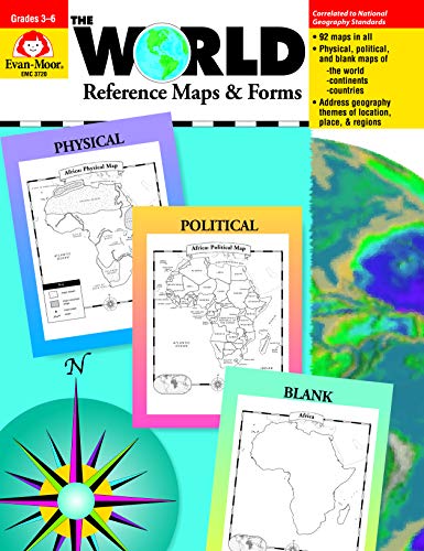
The World Reference Maps & Forms contains 92 maps, evaluation forms, a crossword puzzle, a word search, and an answer key.
The first section, The World, includes:
-an introduction of general facts about the world-a list of 192 countries in the world-a reference political map of the continents-a blank world map-Robinson and Mercator projection maps-globes, showing hemispheres, parallels, and meridians-maps of oceans, rivers, mountain ranges, and deserts The second section, The Continents, includes:
North America:
-an introduction, listing the countries, area, population, elevations, and fun facts about the continent-reference political and physical maps of North America, Canada, the United States, and Mexico-blank outline maps of North America, Canada, the United States, and Mexico shape, political, and -physical-study maps of each region of the United States and Mexico and the provinces and territories of Canada-a reference map of six regions of the United States-study maps of Central America, the Greater Antilles, and a reference map of the Lesser Antilles
South America
-an introduction, listing the area, elevations, and fun facts about the continent-a reference political map and physical map of South America and Northern South America-blank outline maps of the continent shape, political, and physical
Africa, Europe, Asia, and Australia
-an introduction, listing the countries, area, population, elevations, and fun facts about the continent
-a reference political and a physical map of the continent (a political map of Oceania is included with Australia)
-blank outline maps of the continent shape, political, and physical
-study maps of regions of the continent
Antarctica and the Arctic Region
-an introduction, listing the area, elevations, and fun facts about the continent
-reference polar projection maps of Antarctica and the Arctic Region
-a reference map of the scientific stations in Antarctica
-blank outline projection maps of Antarctica and the Arctic Region
This resource contains teacher support pages, reproducible student pages, and an answer key.
Product Features
- Weight – 0.75
- Depth – 8.50
- Width – 11.00
- Height – 0.31
Audible Annual Paid Membership
Gift of Audible 12-month Membership Plan
Kindle Unlimited 24 Month Paid Membership
Audible PLUS Paid Digital Membership
Gift of Audible 3-month Membership Plan
Gift of Audible 6-month Membership Plan
Gift of Audible 1-month Membership Plan
Kindle Unlimited 12 Month Paid Membership
SNAP EBT Enrollment
Audible PLUS Free Trial Digital Membership
The Drop Text Alerts
Kindle Unlimited 6 Month Paid Membership
Amazon Prime for Young Adults 6-month Trial
Amazon Baby Registry
Amazon Wedding Registry
Amazon Prime Free Trial
Kindle Unlimited Free Trial
Amazon Home Services
Prime Gaming
Amazon Prime Discounted Monthly Offering
Amazon Kids+ Free Trial
Amazon Kids+ Special Promotions
Prime Try Before You Buy First Box Checkout
Amazon Music Unlimited Monthly Subscription
Amazon Music Unlimited Digital Bundle
Amazon Prime Video Free Trial
This post contains affiliate links. As an Amazon Associate I earn from qualifying purchases